Early in March this year rangers arrived at the Namadgi National Park visitor information centre to see that a major rockslide had occurred during the night, gouging a pale stripe down three quarters of the mountains’ north-east face.
The landslip looks pretty dramatic close up, but driving around Tuggeranong it is clear that it is even more striking from a distance.

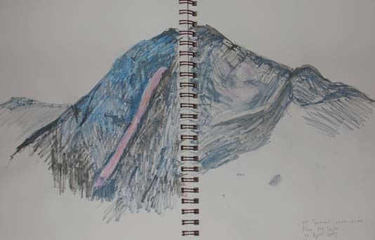
So this weeks exercise involved just that, climbing up Mt Taylor to get a good view of Mt Tennant. I made the following drawing using watercolour pencils.
It turns out that you can also see a man-made gash in the side of the Bullen Range, I presume it is a fire trail, quite rusty-orange against the vegetation, compared to the decidedly pink colour of the rockslide on Mt Tennant. This picture takes a ‘slice’ from Mt Gingera, down through Tidbinbilla Nature Reserve and into the forground of the Bullen Range.


[…] the first time since April 2012 I’ve climbed Mt Taylor. This is a major achievement for me post knee replacement. I knew I […]
LikeLike
[…] home, I saw nearby Mt Tennant, with a cap of low cloud over it’s peak and the scar from the landslide in 2012, still visible. I chose to use two watercolour pencils held together. I varied the colours, […]
LikeLike
Strong, colourful detail. Many would tackle the subject as black and white
LikeLike
Thanks. I’m a big colour person. I can and do use black and white, but often when I have to get something down quickly like when I am travelling.
LikeLiked by 1 person